Showing posts with label Environment. Show all posts

Earth's climate to increase by 4 degrees by 2084


A collaborative research team from China has published a new analysis that shows the Earth's climate would increase by 4 °C, compared to pre-industrial levels, before the end of 21st century.

Earth's climate to increase by 4 degrees by 2084
The levels of future global warming relative to the pre-industrial period have been extensively addressed, in which 2 C
and 1.5 C warming have attracted the most attention. A special report 'Turn Down the Heat: Why a 4°C Warmer World
must be Avoided' by the World Bank in 2012 described a 4 C warmer world with significant changes in mean
and extreme climates on the basis of earlier-generation climate models and emission scenarios
[Credit: ParabolStudio/Shutterstock]
To understand the severity of this, consider the Paris Agreement of the United Nations. It's a global effort to prevent an increase of 2°C. Nearly every country on the planet--the United States is the only country to withdraw--has agreed to work to prevent the catastrophic effects of two degrees of warming.

The researchers published their analysis projecting a doubling of that increase in Advances in Atmospheric Sciences.

"A great many record-breaking heat events, heavy floods, and extreme droughts would occur if global warming crosses the 4 °C level, with respect to the preindustrial period," said Dabang Jiang, a senior researcher at the Institute of Atmospheric Physics of the Chinese Academy of Sciences. "The temperature increase would cause severe threats to ecosystems, human systems, and associated societies and economies."

In the analysis, Jiang and his team used the parameters of scenario in which there was no mitigation of rising greenhouse gas emissions. They compared 39 coordinated climate model experiments from the fifth phase of the Coupled Model Intercomparison Project, which develops and reviews climate models to ensure the most accurate climate simulations possible.

They found that most of the models projected an increase of 4°C as early as 2064 and as late as 2095 in the 21st century, with 2084 appearing as the median year.

This increase translates to more annual and seasonal warming over land than over the ocean, with significant warming in the Arctic. The variability of temperature throughout one year would be lower in the tropics and higher in polar regions, while precipitation would most likely increase in the Arctic and in the Pacific. These are the same effects that would occur under 1.5°C or 2°C increases, but more severe.

"Such comparisons between the three levels of global warming imply that global and regional climate will undergo greater changes if higher levels of global warming are crossed in the 21st century," wrote Jiang.

The researchers continue to investigate the changes associated with 4°C of global warming in extreme climates.

"Our ultimate goal is to provide a comprehensive picture of the mean and extreme climate changes associated with higher levels of global warming based on state-of-the art climate models, which is of high interest to the decision-makers and the public," said Jiang.

Source: Institute of Atmospheric Physics, Chinese Academy of Sciences [May 23, 2018]

Critically endangered South American forests were man made


Critically endangered South American forests thought to be the result of climate change were actually spread by ancient communities, archaeologists have found.

Critically endangered South American forests were man made
Campos da Serra y Floresta de Araucari [Credit: Copyright Jose Iriarte]
Huge swathes of land in Chile, Brazil and Argentina are covered with millions of Araucaria, or monkey puzzle trees, thanks to people planting or cultivating them more than a thousand years ago, a new study shows. Recent logging means the landscape is now one of the world's most at-risk environments.

It had been thought the forests expanded due to wetter and warmer weather. But the research shows the rapidly expanding pre-Columbian population of South America, Southern Jê communities, were really responsible.

New excavations and soil analysis shows the forests, still hugely culturally and economically important to people living in South America, expanded between 1,410 and 900 years ago because of population growth and cultural changes.

Dr Mark Robinson, from the University of Exeter, who led the British Academy and AHRC-FAPESP-funded research, said: "Our research shows these landscapes were man-made. Communities settled on grassland, and then - perhaps because they modified the soil, protected seedlings or even planted trees - established these forests in places where geographically they shouldn't have flourished."

Critically endangered South American forests were man made
Monkey puzzle forests [Credit: Copyright Mark Robinson]
The forests date back to the period when dinosaurs roamed. The iconic monkey puzzle tree, or Parana pine, has grown in the region for thousands of years. Its nuts were one of the most important food sources for ancient communities, attracted game for hunting when nuts were ripe. They were also a valuable source of timber, fuel and resin, and became an integral part of southern Jê cosmology. Communities still call themselves "people of the Araucaria", and hold festivals to celebrate the forests.

Of the 19 species of Araucaria tree, five are classified as endangered and two, including the Brazilian Araucaria angustifolia, are critically endangered. Reports from the late 1800s describe trees with diameters of over 2 m, reaching 42 m in height. Modern trees are only around 17.7 m tall.

The archaeological analysis began because the experts, from the University of Exeter, University of Reading, University of São Paulo, University of New Mexico, Universidade Federal de Pelotas and Universidade do Sul de Santa Catarina, noticed that in areas of low human activity forests are limited to south-facing slopes, whereas in areas of extensive archaeology, forests cover the entire landscape. They were able to analyse soil isotopes reflecting vegetation and archaeological evidence from Campo Belo do Sul, Santa Catarina State, Brazil, to test whether this pattern was directly related to past human activity.

The study shows the forests first expanded around 4,480 to 3,200 years ago, most likely near streams, and this may have been caused by a wetter climate. But a more rapid and extensive expansion across the whole region later happened between 1,410 and 900 years ago, when forests expanded into highland areas. The weather during this time was dry and less humid. This expansion of the forests coincides with population growth and increasingly complex and hierarchical societies in South America.

Critically endangered South American forests were man made
Monkey puzzle forests [Credit: Copyright Mark Robinson]
The expansion in forests reached a peak around 800 years ago. The number of people in South America declined 400 years ago when European settlers arrived in the area. The population did not begin to recover until the 19 century, when loggers began exploiting the Araucaria forests for timber.

Professor José Iriarte, from the University of Exeter, another member of the research team, said: "This study shows the Araucaria forests were expanded beyond their natural boundaries, they were used sustainably for hundreds of years, and conservation strategies must reflect this so they balance protection, heritage and economic development."

The study is published in the journal Scientific Reports.

Source: University of Exter [May 17, 2018]

Study shows one third of world's protected areas degraded by human activities


A shocking study in the journal Science by the University of Queensland, Wildlife Conservation Society (WCS), and University of Northern British Columbia confirms that one third of the world's protected areas - an astonishing 2.3 million square miles or twice the size of the state of Alaska - are now under intense human pressure including road building, grazing, and urbanization.

Study shows one third of world's protected areas degraded by human activities
Some of these least impacted protected areas include Madidi National Park in Boliviawhere WCS has made
considerable conservation investments and therefore has successfully staved off degradation
[Credit: Rob Wallace/WCS]
The study is a reality check for nations striving to meet commitments under the Convention on Biological Diversity (CBD) to halt biodiversity loss through protected area creation. Since 1992, the global extent of protected areas has roughly doubled in size; more than 202,000 cover more than 15 percent of the world's terrestrial area, with a goal of at least 17 percent coverage by 2020.

Though management objectives differ, ranging from strict biodiversity conservation areas to zones permitting certain human activities and sustainable resource extraction, the primary goal of all protected areas is to conserve nature.

The authors looked at global "Human Footprint" maps to make their assessment which shows that 32.8 percent of protected land is highly degraded. For protected areas created before the CBD was ratified 1992, 55 percent have since experienced human pressure increases. The authors warn that CBD goals will be severely undermined if widespread human pressure continues inside protected areas.

Said the paper's lead author, Kendall Jones of University of Queensland: "A well-run protected area network is essential in saving species. If we allow our protected area network to be degraded there is a no doubt biodiversity losses will be exacerbated."

The study shows that governments are overestimating the space available for nature inside protected areas. Governments are claiming these places are protected for the sake of nature when in reality they aren't. It is a major reason why biodiversity is still in catastrophic decline, despite more and more land being 'protected'.

However, the authors are not suggesting that high pressure protected areas be de-gazetted or defunded. To the contrary, it is crucial that nations recognize the profound conservation gains that can be realized by upgrading and restoring degraded protected areas while respecting the needs of local people.

The Good News

The most impacted protected areas were found in Asia, Europe, and Africa in places with massive human populations. But the study did find some good news: protected areas with strict biodiversity conservation objectives are subject to significantly lower levels of human pressure.

Some of these least impacted protected areas include Keo Seima Wildlife Sanctuary in Cambodia, Madidi National Park in Bolivia, and Yasuni Biosphere Reserve in Ecuador - places where WCS has made considerable conservation investments and therefore has successfully staved off degradation.

Said Professor James Watson of WCS and University of Queensland, and the study's senior author: "We know protected areas work - when well-funded, well-managed and well placed, they are extremely effective in halting the threats that cause biodiversity loss and ensure species return from the brink of extinction. There are also many protected areas that are still in good condition and protect the last strongholds of endangered species worldwide. The challenge is to improve the management of those protected areas that are most valuable for nature conservation to ensure they safeguard it."

Protected areas are at the core of WCS's conservation strategy, as these are areas that are most effective at protecting natural ecosystems and their complement of biodiversity and ecosystem services - over 80 percent of WCS's site-based field work takes place within or around protected areas. When well-managed (through sound enforcement, monitoring, clear boundaries) and funded appropriately, protected areas are effective in reducing the loss of natural habitat, and sustaining wildlife populations.

Said Watson: "Most importantly we've got to recognize that these jewels in the crown need support- there are some protected areas that are safeguarding nature and that still haven't got any evidence of human encroachment in them. We must ensure these values are maintained."

Source: Wildlife Conservation Society [May 17, 2018]

Limiting warming to 1.5 degree C would save majority of global species from climate change


Limiting global warming to 1.5°C would save the vast majority of the world's plant and animal species from climate change - according to new research led by the University of East Anglia.

Limiting warming to 1.5 degree C would save majority of global species from climate change
The American pika is considered an indicator species for detecting ecological effects of climate change
in mountainous regions [Credits: NPS]
A new report published in Science reveals that limiting warming to the ultimate goal of the Paris Agreement would avoid half the risks associated with warming of 2°C for plants and animals, and two thirds of the risks for insects.

Species across the globe would benefit - but particularly those in Southern Africa, the Amazon, Europe and Australia.

Reducing the risk to insects is particularly important, the team say, because they are so vital for 'ecosystem services' such as pollinating crops and flowers, and being part of the food chain for other birds and animals.

Previous research focused on quantifying the benefits of limiting warming to 2°C above pre-industrial times - the upper limit for temperature as set out in the Paris Agreement - and did not look at insects.

This is the first study to explore how limiting warming to 1.5°C would benefit species globally.

Researchers at UEA and James Cook University in Australia studied some 115,000 species including 31,000 insects, 8,000 birds, 1,700 mammals, 1,800 reptiles, 1,000 amphibians and 71,000 plants in this, the largest scale study of its kind.

Lead researcher Prof Rachel Warren, from the Tyndall Centre for Climate Change Research at UEA, said: "We wanted to see how different projected climate futures caused areas to become climatically unsuitable for the species living there.

"We measured the risks to biodiversity by counting the number of species projected to lose more than half their geographic range due to climate change.

"We found that achieving the ultimate goal of the Paris Agreement, to limit warming to 1.5°C above pre-industrial levels, would reap enormous benefits for biodiversity - much more so than limiting warming to 2°C.

"Insects are particularly sensitive to climate change. At 2°C warming, 18 per cent of the 31,000 insects we studied are projected to lose more than half their range.

"This is reduced to 6 per cent at 1.5°C. But even at 1.5°C, some species lose larger proportions of their range.

"The current global warming trajectory, if countries meet their international pledges to reduce CO2, is around 3°C. In this case, almost 50 per cent of insects would lose half their range.

"This is really important because insects are vital to ecosystems and for humans. They pollinate crops and flowers, they provide food for higher-level organisms, they break down detritus, they maintain a balance in ecosystems by eating the leaves of plants, and they help recycle nutrients in the soil.

"We found that the three major groups of insects responsible for pollination are particularly sensitive to warming.

"If temperatures rise by 3°C, ecosystem services provided by insects would be greatly reduced. Other research has already shown that insects are already in decline for other reasons, and this research shows that climate change would really compound the problem."

The study includes the ability of species to relocate to more suitable locations as the world warms. Birds, mammals and butterflies have the greatest ability to disperse. The dispersal means that a small number of species can gain in range by 2100.

Prof Warren added: "If warming is limited to 1.5°C by 2100 then more species can keep up or even gain in range, whereas if warming reached 2°C by 2100 many species cannot keep up and far more species lose large parts of their range."

Co-author Dr Jeff Price, also from UEA, added: "Examples of animals to really benefit from limiting warming to 1.5 include the critically endangered Black Rhinoceros, which is already highly threatened by poaching and habitat loss.

"There are also species which have been important in evolutionary theory and studied since the time of Charles Darwin, which would benefit from limiting warming to 1.5°C. These include Darwin's Finches of the Galapagos, such as the Large Ground Finch."

Source: University of East Anglia [May 17, 2018]

Satellite study finds major shifts in global freshwater


A new global, satellite-based study of Earth's freshwater distribution found that Earth's wet areas are getting wetter, while dry areas are getting drier. The data suggest that this pattern is due to a variety of factors, including human water management practices, human-caused climate change and natural climate cycles.

Satellite study finds major shifts in global freshwater
This global map of freshwater stored on land for February 2016 using data from
 the Gravity Recovery and Climate Experiment [Credit: NASA]
The NASA-led research team, which included Hiroko Beaudoing, a faculty specialist at the University of Maryland's Earth System Science Interdisciplinary Center (ESSIC), used 14 years of observations from the Gravity Recovery and Climate Experiment (GRACE) mission to track global trends in freshwater in 34 regions around the world.

The study, published in the journal Nature, also incorporated satellite precipitation data from the ESSIC-led Global Precipitation Climatology Project; Landsat imagery from NASA and the U.S. Geological Survey; irrigation maps; and published reports of human activities related to agriculture, mining and reservoir operations. The study period spans from 2002 to 2016.

"This is the first time we've assessed how freshwater availability is changing, everywhere on Earth, using satellite observations," said Matt Rodell, lead author of the paper and chief of the Hydrological Sciences Laboratory at NASA's Goddard Space Flight Center. "A key goal was to distinguish shifts in terrestrial water storage caused by natural variability -- wet periods and dry periods associated with El Niño and La Niña, for example -- from trends related to climate change or human impacts, like pumping groundwater out of an aquifer faster than it is replenished."

Freshwater is present in lakes, rivers, soil, snow, groundwater and glacial ice. Its loss in the ice sheets at the poles -- attributed to climate change -- has implications for sea level rise. On land, it is one of Earth's most essential resources for drinking water and irrigation. While some regions' water supplies are relatively stable, others normally experience increases or decreases. But the current study revealed a new and distressing pattern.

"What we are witnessing is major hydrologic change," said co-author James Famiglietti of NASA's Jet Propulsion Laboratory. "We see, for the first time, a very distinctive pattern of the wet land areas of the world getting wetter -- those are the high latitudes and the tropics -- and the dry areas in between getting dryer. Embedded within the dry areas we see multiple hotspots resulting from groundwater depletion."

Famiglietti noted that while water loss in some regions is clearly driven by warming climate, such as the melting ice sheets and alpine glaciers, it will take more time before other patterns can be unequivocally attributed to climate change.

"The pattern of wet-getting-wetter, dry-getting-drier is predicted by the Intergovernmental Panel on Climate Change models for the end of the 21st century, but we'll need a much longer dataset to be able to definitively say that climate change is responsible for the emergence of a similar pattern in the GRACE data," Famiglietti said. "However, the current trajectory is certainly cause for concern."

NASA scientists used GRACE data to identify regional trends of freshwater movement, and combined that information 
with data from other satellites, climate models and precipitation measurements to determine the causes 
of major regional trends in freshwater storage [Credit: NASA/Katy Mersmann]
The twin GRACE satellites, launched in 2002 as a joint mission with the German Aerospace Center (DLR), precisely measured the distance between the two satellites to detect changes in Earth's gravity field caused by movements of mass on the planet below. Using this method, GRACE tracked variations in terrestrial water storage on monthly to yearly timescales until its science mission ended in October 2017.

However, the GRACE satellite observations alone couldn't tell Beaudoing, Rodell, Famiglietti and their colleagues what was causing an apparent trend.

"We examined information on precipitation, agriculture and groundwater pumping to find a possible explanation for the trends estimated from GRACE," said Beaudoing, who also has a joint appointment at NASA Goddard.

One of the big causes of groundwater depletion across the board was agriculture, which can be complicated by natural cycles as seen in California, Famiglietti said. Decreases in freshwater caused by the severe drought from 2007 to 2015 were compounded by groundwater withdrawals to support the farms in the state's Central Valley.

Southwestern California lost 4 gigatons of freshwater per year during the same period. A gigaton of water is the equivalent of the mass of water in 400,000 Olympic swimming pools. A majority of California's freshwater comes in the form of rainfall and snow that collects in the Sierra Nevada as snowpack and then is managed through a series of reservoirs as it melts. When natural cycles led to dry years, causing diminished snowpack and surface waters, people relied on groundwater more heavily.

Downward trends in freshwater seen in Saudi Arabia also reflect agricultural pressures. From 2002 to 2016, the region lost 6.1 gigatons per year of stored groundwater. Imagery from the Landsat series of satellites shows the growth of irrigated farmland in the arid landscape from 1987 to the present, which explains the increased drawdown.

Natural cycles of rainy and dry years can also cause a trend in the 14-year data record that is unlikely to persist, Rodell said. An example is the western Zambezi basin and Okavango Delta, a vital watering hole for wildlife in northern Botswana. In this region, terrestrial water storage increased at an average rate of 29 gigatons per year from 2002 to 2016. This wet period during the GRACE mission followed at least two decades of dryness. Rodell believes this is a case of natural variability that occurs over decades in this region of Africa.

The researchers found that a combination of natural and human pressures can lead to complex scenarios in some regions. Previously undocumented water declines occurred in northwestern China in Xin Jiang province. This region, about the size of Kansas, is bordered by Kazakhstan to the west and the Taklamakan desert to the south and encompasses the central portion of the Tien Shan Mountains.

Rodell and his colleagues had to piece together multiple factors to explain the disappearance of 5.5 gigatons of terrestrial water storage per year in Xin Jiang Province. Less rainfall was not the culprit. Additions to surface water were also occurring from climate change-induced glacier melt and the pumping of groundwater out of coal mines. But these additions were more than offset by depletions caused by an increase in water consumption for the irrigation of cropland and evaporation of river water from the desert floor.

The successor to GRACE, called GRACE Follow-On, a joint mission with the German Research Centre for Geosciences (GFZ), is at Vandenberg Air Force Base in California undergoing final preparations for launch.

Source: University of Maryland [May 16, 2018]

Climate change may even threaten one of the world's most resilient lizards


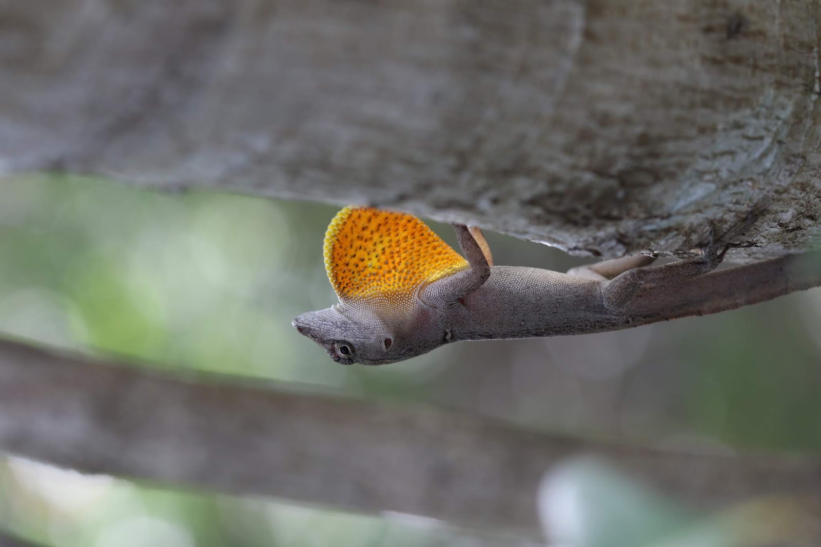
Sporting a bright red-and-yellow dewlap under its chin, the color-changing Bahamian anole lizard is a popular exotic pet. This wily anole has escaped captivity on enough occasions to successfully invade large areas across the Western Hemisphere. At first glance, this suggests that the anole is well-suited to adapt to a changing climate. But a new study led by a Smithsonian researcher, suggests that may not be the case.

Climate change may even threaten one of the world's most resilient lizards
A Bahamian anole lizard (Anolis sagrei) perches in its native terrain in the Bahamas
[Credit: Michael Logan]
Michael Logan, post-doctoral fellow at the Smithsonian Tropical Research Institute in Panama, studies the brown anole in its home range in the Bahamas. His most recent study shows that the anole's genetic makeup is surprisingly ill-suited to future climate scenarios. The anole is therefore unlikely to adapt fast enough to keep pace with current rates of environmental change.

The findings, published in Proceedings of the Royal Society B, have important implications for the future of cold-blooded species (such as other reptiles, amphibians and fish), especially since rapid evolution is considered a key way for many of these species to survive a global increase in temperatures.

"Brown anoles have huge population sizes and therefore should have loads of genetic variation in most traits, permitting rapid adaptation," Logan said. "Instead, we found that genetic variation in several traits that are critical under climate change is basically zero."

Brown anoles are ectotherms: they rely on the temperature of the environment to control their body heat. When they are too cold, they shuffle off to a sunny spot and soak up heat. When they are too hot, they seek shade or cooler spots. Maintaining an optimal body temperature is a basic component for success at essentials of life--moving, eating and reproducing.

For the study, Logan and colleagues captured brown anoles from two different, isolated habitats in the Bahamas. One is relatively cool and forested; the other is a hot, sun-soaked peninsula. In laboratory conditions, they raised hundreds of offspring from these two populations and, after they reached adulthood, challenged them in some simple trials.

To evaluate physical performance at different body temperatures, they used a high-speed camera to film the lizards as they ran across a wooden dowel rod. To better understand how they behaved when exposed to environments of different temperatures, they used gel packs and heating lamps to create an environment that ranged from 20 degrees C to 48 degrees C and recorded where the lizards moved and how they adjusted to changes in temperature. To understand the offspring's inherited traits -- and thus evaluate their potential to evolve -- they ran a series of analyses.

The results surprised across the board, especially since the different lizard populations had long been isolated in highly contrasting environments. While the researchers found some evidence that the populations were adapted to their local environments, genetic results suggested the lizards have little built-in capacity to inherit traits that would allow them to evolve apace with climate change. One possible explanation is that strong selection pressure in the past, which caused them to be adapted to different environments in the first place, eliminated future genetic variation that may be required.

"If genetic variation in thermal traits is rock bottom for a species like the brown anole that has huge population sizes and a super-wide geographic distribution," asks Logan, "what will it be for most other species that typically have much smaller population sizes and live relatively isolated, specialized lifestyles?"

Source: Smithsonian Tropical Research Institute [May 09, 2018]

For lemurs, size of forest fragments may be more important than degree of isolation


Occurrence probability of three lemur species in tropical dry forest increases with fragment size but can increase or decrease with fragment isolation depending on the species, according to a study published in the open-access journal PLOS ONE by Travis Steffens and Shawn Lehman from University of Toronto, Canada.

For lemurs, size of forest fragments may be more important than degree of isolation
A common brown lemur (Eulemur fulvus) [Credit: Travis S. Steffens]
Lemurs live only in Madagascar, and nearly all species are at risk of extinction primarily due to habitat loss and fragmentation. The independent effects of forest loss and of forest fragmentation are not well understood, however. To assess the relative impact of these threats, Steffens and Lehman surveyed lemurs in fragmented dry deciduous forest in Ankarafantsika National Park, Madagascar between June and November 2011, observing six lemur species in 42 forest fragments. The researchers then used incidence function models to examine whether the lemurs formed metapopulations, spatially-separated populations within a species, in a fragmented landscape and under different forest fragmentation conditions.

In their simulations, the researchers found that three of the lemur species did form metapopulations in forest fragments. Within these metapopulations, occurrence was affected by both forest fragment size and isolation. However, fragment size appeared to be more important in determining lemur occurrence, with larger forest patches being associated with increased lemur occurrence.

Madagascan forests are becoming increasingly fragmented, and this work helps to clarify how lemurs respond. It appears to be helpful to use a metapopulation approach when studying lemurs, and maintenance of habitat area may be crucial to maintaining populations in this fragmented landscape.

"Some lemur species are capable of tolerating high levels of habitat loss and fragmentation by forming metapopulations," says Travis Steffens. "In metapopulations occurrence probability is positively related to habitat area for each species while isolation has species-specific positive, negative and neutral impacts on occurrence probability."

Source: PLOS [May 09, 2018]

The Baltic Sea as a time machine


At first glance, the Baltic Sea seems to be rather uninteresting for scientists working on global ocean topics. It is comparatively shallow, has a low salinity and only a very narrow connection to the North Atlantic. This impression is, however, deceiving. In the current issue of the international journal Science Advances, 26 authors from 21 scientific institutions in seven countries appeal to the greater scientific community and policy makers to use the Baltic Sea Region as a model for coming changes in the World Ocean. "This unique sea of brackish water can serve as a kind of time machine that allows us to better estimate future global changes," says Prof. Thorsten Reusch from the GEOMAR Helmholtz Center for Ocean Research Kiel, one of the lead authors of the article.

The Baltic Sea as a time machine
The Baltic Sea can be regarded as a model area for changes in the world ocean
[Credit: Christoph Kersten, GEOMAR]
The scientists argue that changes that are only expected for the future in the global ocean can already be observed in the Baltic today. "This is because the small volume of water and slow water exchange with the open ocean, behaves like an amplifier, allowing many processes and interactions to occur at a faster pace", emphasizes Dr. Jan Dierking from GEOMAR, who initiated the study together with Prof. Reusch.

As examples, the oceans have warmed by an average of 0.5°C over the past 30 years, while in the same period, time-series measurements in the Baltic Sea have recorded warming of around 1.5°C. Likewise, there are large oxygen-free zones in the deep areas of the Baltic Sea, which have increased tenfold over the past century; and the pH--a measure of ocean acidification--of Baltic waters regularly reaches values that are expected in other ocean areas only in the next century.

The Baltic Sea as a time machine
Water sampler on RV LITTORINA in the Baltic [Credit: GEOMAR]
On the one hand, these extremes are caused by the particular basin topography of the Baltic Sea. On the other hand, intensive use by humans continues to accelerate negative changes. Nine countries border on the Baltic Sea directly and all are highly industrialized, with densely populated coastal regions. Moreover, intensive agriculture in the interior ensures high nutrient runoff, while equally intensive fisheries puts pressure on the pelagic food-web.

But it's not all doom and gloom. The Baltic Sea is one of the best-surveyed seas on Earth. Scientific observation and monitoring of physical and biological processes began around 1900. There is a strong tradition in scientific co-operation among many countries surrounding the Baltic, culminating in the implementation of the joint Baltic Sea research and development programme BONUS of the European Union, a dedicated macro-regional research agenda and funding scheme that also enabled the present study. These data provide a sound basis for science-based resource management--"on a level accomplished in only a few regions of the world," emphasizes Professor Reusch.

The Baltic Sea as a time machine
Collection of water samples on RV LITTORINA [Credit: GEOMAR]
Among the management success stories: the bordering countries have managed to significantly reduce nutrient inputs since the 1980s, to reverse the decline of large predators, and to curb overfishing. This has been achieved through the binding agreements within the framework of the European Union, but also thanks to the ambitious goals of the Baltic Sea Action Plan (BSAP), which included Russia, even before the end of the Cold War. In fisheries, the protection of capture fisheries, marine mammals and bird populations among the perimeter countries have led to measurable improvements of existing stocks.

"Overfishing, warming, acidification, pollution, eutrophication, loss of oxygen, intensive use of coasts--all these are phenomena that we observe around the globe. Because they have been particularly drastic in the Baltic, but also because some key problems were successfully addressed, the region can, for good and for bad, tell us what to expect and how to respond to the challenges of the future," Prof. Reusch concludes, "The Baltic Sea, as a model region, can contribute to achieving the United Nation's Sustainable Development Goal 14--the conservation and sustainable use of the oceans, seas and marine resources."

Source: Helmholtz Association of German Research Centres [May 09, 2018]

Scientists hark back to Pleistocene to trace prioritary areas for conservation


Identifying priority areas for action is a major challenge in biodiversity conservation projects. A group of researchers have chosen an approach based on past scenarios to try to understand the history of climate conditions in the regions analyzed.

Scientists hark back to Pleistocene to trace prioritary areas for conservation
Atlantic Forest Fragmentation [Credit: Cnes - Spot Satellite Image via Wikimedia]
"The regions that have suffered least from climate change in the last 21,000 years are those in which the fewest local extinctions have occurred. These regions stand out for their higher species richness ratios, genetic diversity among species and gene variability within the same population," said Thadeu Sobral-Souza, a biologist at the Rio Claro campus of São Paulo State University (UNESP) in Brazil.

The greater a population's genetic diversity, the higher its chances of surviving environmental change. Sobral-Souza is one of the authors of a paper that describes a methodology to identify climatically stable Amazon and Atlantic Rainforest areas that can be prioritized in conservation strategies. The study also determined which protected areas are already located in climatically stable areas.

Some of the group's findings have been published in the journal Acta Oecologica. The research was supported by the São Paulo Research Foundation - FAPESP via a project in which Milton Cezar Ribeiro, a professor in UNESP Ecology Department, was principal investigator.

To determine which areas are climatically stable, the researchers first had to estimate the distributions of both biomes in the past, especially before most of the Atlantic Rainforest was destroyed. They used ecological niche modeling to simulate the distribution of these forests both now and in previous eras.

New technologies have facilitated the development of techniques to generate useful information from incomplete data. Species ecological niche modeling is one example. All species of animals and plants obey ecological rules that determine their geographical distribution. Even partial knowledge of the geographical distribution of a species in the present and the levels of environmental variation it tolerates (temperature highs and lows, rainfall, and so on) can be fed into computer algorithms and geoprocessing tools to obtain a quantitative representation of its ecological distribution.

Incomplete data for the geographical location of a species can be used to discover its current (or potential) distribution in the environment. Similarly, estimates of past climate conditions can be used to simulate the spatial distribution of species in previous periods.

"Although ecological niche modeling is normally used to infer species distribution, the technique is also deployed to predict biome delimitation by modeling the biome," Sobral-Souza said.

To predict variations in biome distribution over time, the researchers selected occurrence points using a geographical filter based on the current delimitations of the Amazon and Atlantic Rainforest biomes. Several atmosphere-ocean global circulation models that infer past global climate currently exist. "We used five of these models as data sources for simulations of the Amazon and Atlantic Rainforest climate in the past," Sobral-Souza said.

The researchers estimated the distributions of the two biomes using data such as annual mean temperature and annual precipitation as variables. The models were constructed on the basis of the current climate scenario and simulated past scenarios for the peak of the last ice age in the Late Pleistocene, 21,000 years ago, and the middle of the Holocene, 6,000 years ago.

Scientists hark back to Pleistocene to trace prioritary areas for conservation
Map of the Atlantic Forest ecoregions as delineated by the WWF. The yellow line approximately
 encloses the forest's distribution [Credit: NASA 
via Wikimedia]
The simulations showed that the potential area of the Amazon biome 21,000 years ago was 3.28 million km², compared with a current potential area of 4.46M km², while the corresponding numbers for the Atlantic Rainforest were 3.85M km² and only 770,000 km², an 80% decrease.

To calculate climatically stable areas in the two biomes, the researchers superimposed the two paleomaps showing the biomes' distributions 21,000 and 6,000 years ago onto the map of their current distribution, thereby selecting the areas predicted to be suitable for biome occurrence in the three scenarios.

"Once we'd identified the overlaps showing climatically stable areas in all the scenarios, we analyzed the efficiency of currently protected areas," Ribeiro said.

They did this by mapping all protected areas and superimposing this map on the previous ones to show which protected areas were inside climatically stable areas and which were not.

To propose priority conservation areas, they mapped unprotected climatically stable areas and used the Intact Forest Landscapes database to infer which of these unprotected areas contain intact remnants of primary forest without anthropogenic modification, considering only large connected patches and excluding small or unconnected remnants.

Climate stability

Next, the researchers assigned each of these patches to one of three conservation priority categories. Very high priority areas were climatically stable, unprotected, and with large intact forest remnants.

High priority areas, the second category, were climatically stable, unprotected, and with fragmented forest remnants. The third category comprised medium priority areas, with more recent climate stability (in the last 6,000 years) and unprotected intact forest remnants.

"The results revealed three unconnected blocks of climatically stable areas in the Atlantic Rainforest biome, all near the coast," Ribeiro said. "The northernmost block comprises Paraíba and Pernambuco States all the way along the Zona da Mata region. The second coincides with the Serra do Mar and Serra da Mantiqueira ranges in São Paulo State, Serra dos Órgãos in Rio de Janeiro State, and Zona da Mata in Minas Gerais.

"In the Amazon, the climatically stable areas are broad and continuous, covering most of the currently existing biome. Most of them occur in eastern Amazonia, although smaller remnants were identified along the western and southern boundaries of the forest."

The researchers created an efficiency index, defined as the percentage of protected areas that encompass climatically stable areas. They inferred higher efficiency for protected areas in the Amazon than for those in the Atlantic Rainforest, finding that 40.1% of climatically stable areas in the Amazon are protected, compared with only 7.1% of climatically stable areas in the Atlantic Rainforest.

"The Amazon is more stable climatically than the Atlantic Rainforest, and protected areas in the latter are less efficient than protected areas in the former," Ribeiro said.

Scientists hark back to Pleistocene to trace prioritary areas for conservation
Amazon raiforest, Brazil [Credit: Lunae Parracho/AFP/Getty Images]
In the Amazon, the study identified climatically stable areas in all three conservation priority categories - very high priority, high priority and medium priority. The areas of very high conservation priority in the Amazon biome are primary forest areas of western Amazonas State in the region bordering Peru, Colombia and Venezuela.

"Its geographical proximity to protected areas suggests that the creation of new protected areas or the enlargement of existing areas to include these high-priority areas could be an effective conservation strategy," Sobral-Souza said.

The high-priority areas in the Amazon are fragmented forests in climatically stable areas and are therefore in need of restoration. The high priority areas in western Amazonia are located near existing protected areas or intact fragments. In eastern Amazonia, they are forest patches surrounded by croplands and pasture, distant from intact forest areas.

"In these cases, reforestation is necessary to increase the efficiency of the protected areas in the region. The Amazon still has a major opportunity to expand conservation areas," Ribeiro said.

Sobral-Souza stressed that the situation is catastrophic in the Atlantic Rainforest biome. "No high-priority areas for conservation were identified because no more forest areas exist there. No intact forest or even fragments are left. Everything has been cleared in the last 500 years," he said.

The main climatically stable Atlantic Rainforest areas are small. They are relicts classified as high priority conservation areas. Only a few remnants exceed 10,000 hectares, and many occur in areas with low climate stability. The most important are in Pernambuco's Zona da Mata or the Serra do Mar State Park, "the largest Atlantic Rainforest remnant in Brazil," Sobral-Souza noted.

Source: São Paulo Research Foundation – FAPESP [May 04, 2018]